Bill, Ben and I did Windy Creek packraft trip on Sunday. It is a favorite day trip to really get out and paddle some easy rapids. It was a beautiful fall day with only a few showers later on.
All the leaves are changing, the leaves were all green a few days ago when we picked berries here.
This was Bill's first packraft trip, but he has navigated many rivers in a canoe and it was not a problem at all.
Bill and Ben negotiating the river.
The river was still high enough for another run before the snow fall in a few weeks. Though, where the Windy Creek tributary entered the Jack River was barley floatable.
8.23.2010
8.18.2010
Cantwell Creek
Heather, Laura and I did the Cantwell Creek Loop. We started up the regular Windy Creek Route, over Foggy Pass and descended down to the Cantwell River. Floated the Cantwell River to the Jack and took out at the bridge over the Jack River in Cantwell. It was a quick, fun overnight trip. Around 20 miles hiking and 20miles to float.
After the 5 mile hike into Windy Creek, we did not follow the narrow ridge down to the East Fork drainage and it was less climbing.....
But, a lot more bushwhacking.
Heading down the final descent to the East Fork, there were a few nice game trails to follow.
We camped at the far end of the drainage before going up Foggy Pass.
The next day we had 10 miles left to hike to the river and 20 mile paddle back to Cantwell.
7.05.2010
Junjik River Packrafting trip
We hiked from mile 315 of the Haul Road up the Ribdon River over the continental divide in the Brooks Range. We traversed the Arctic National Wildlife Refuge and paddled down the Junjik River to the East fork of the Chandalar River and ened in Arctic Village for a flight back to Fairbanks. We saw musk ox, an old rocket, bears and caribou...it was an incredible trip. Here are links to my pictures:
http://www.facebook.com/album.php?aid=2061456&id=1459790183&l=3374ae527a
and Ben's pictures: www.alaskasnapshots.blogspot.com
6.04.2010
Mt. Prindle
Pella and Harriet near the summit of Mt. Prindle. Heather and I had a beautiful hike up Mt. Prindlel from Nome Creek it was 15 miles round trip. Pella and Harriet were a little tired of the rocks, but they both did great.
Wind Chime tors.
The ridge we hiked up in the background. Nice lunch break spot before heading down.
Heather on the way up the vally.
Wind Chime tors.
The ridge we hiked up in the background. Nice lunch break spot before heading down.
Heather on the way up the vally.
Kilo Hot Springs
(photo Ben) November 3148 Mike ( tail dragger plane- 3rd wheel is under the tail)
Leaving Hagglin field next to Martin's house we head to the ridge above Kilo hot springs to meet Ed, Ann and Dan (and Sky!) who paddled the Yukon to the Ray Mountains and hiked 40miles in to the remote hot springs. It was my first flight in a bush plane and Martin was great pilot. He even let me control yoke and fly the plane!
On our way from Fairbanks we stopped on a sand bar on the Yukon River near the village of Rampart.
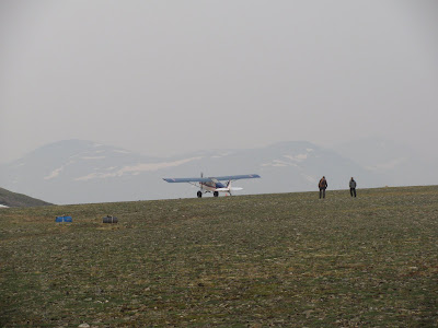
(photo Ed) Martin dropped me off on the ridge while he went to pick up Ben near the Yukon River. A thunderstorm moved in and I was unsure if they would be able to land. After a few passes they landed and in the rain we descended down off the ridge and into the bush to find the hotsprings.
The hiking was not too bad and we were so excited to find Dan, Ed, Ann and Sky amongst the trees. They had seen a grizzly not too far before this and were wondering what was stirring in the trees.
The hot springs were amazing! A section of river with many natural pools at different temperatures.
and room for all!
Right at the hot springs there is a gravel bar that made for great camping. Ben constructed a nice log bench to hang out. The rain ended and 24 hour daylight was nice at midnight.
Spooky valley from the plane and nearing the ridge for a landing.
The next day we all hiked up to the ridge above Kilo and Martin shuttled us out 2 at a time to the Haul Road where Ben had parked a car. The smoke was pretty heavy from wildfires and visibility was lower.
Dan and Sky flew last and Sky loved it.
Martin did several fly bys for Ben on the Haul road, it was quite a rush with him flying so close. Then he landed right next to the road on an abandon airstrip. What an incredible trip with good friends...
5.25.2010
Eleazar's cabin
We started our hike up the summit trail from the Wickersham Dome trail head. The summit trail is in great shape. We hiked past the trail shelter at mile 8 until around mile 10.5 to start our bush whack to Eleazar's cabin in the White Mountains.
We headed toward the cabin off the ridge and half way through we came to a nice clearing to get a view of our direction. The cabin is just beyond the hilltop directly behind Dan's head.
The hiking was not bad off trail some bushwhacking, but mostly trees and a lot of bear scat, though we saw no bears.
The cabin has great views in the summer, but no water. So Dan and Ted hiked 1 mile down to the winter trail and filtered some yummy brown tundra water.
I was able to get a little editing done on a chapter of my thesis. Multitasking my weekends so I can still get out on a great hike.
Dan on the other hand carried his entire biochemistry text book out to the cabin and he really did get some studying in(easy with 24 hours of daylight).
5.17.2010
Packraft day trip! CHST to Middle Fork Chena River
We started out with a beautiful day for our first packraft trip of this year. We headed up Angel Rocks to the ridge and down the back side to find the middle fork of the Chena River and paddle back to the road.
The hike was 12 miles and we followed a winter trail that started near the trail shelter and it was not yet too boggy down towards the middle fork.
We had to bushwhack the last 1/2 mile (or so.....) and a beaver dam flooded the area so in true pack raft trip style we walked through a large area of water before we found the river.
We found a small gravel bar to inflate the boats and had a great paddle back to the road, about 2 hours.Ann stlyin' in her new pack raft boat. The middle fork Chena is a nice mellow float back to the road. We had few twists and turns and that made the day even more memorable!
5.14.2010
Thesis writing, knitting, running, ice and berry jams
Moose Mtn ski area is great for running and hiking up. We have been going on Thursdays and woman's running group intervals on Wednesday...it is shaping up to be a great summer of running, and backpacking/packraft trips. The biggest thing I have on my agenda for the summer is....
..writing my thesis for PhD defense in the beginning of August! I move in and out of the lab to get a better view of the ski trails. We had good timing for the Chatanika River break up and ice jam this year. Though not as massive as the break up of the Yukon River last year, ice jam's are always cool and timing is pretty good thanks to Ed being a hydrologist.
Knitting on the deck at Brown's is a favorite spring time activity in the short period where it is warm enough to knit and the mosquitoes are not taking over. We also made a great batch of Boreal Berry Hat trick Jam- blueberry, raspberry and cranberry.
4.06.2010
Brooks Range
Ben and I had a fantastic short weekend trip to the Brooks Range. The Brooks Range is 100 miles north of the Arctic Circle and around 300 miles north of Fairbanks. We stopped in Wiseman at Bernie and Uda's B&B to say hi to the winter classic guys too.
Atigun Pass was so beautiful, Ben shot the 4x5 and I could not wait to get out the skis. Over the pass it was still winter at -12F, but sunny and no wind.
Team Arctic Thunder with their shaved faces and angry looks. They are getting ready to traverse the Brooks Range on skis and back to Wiseman unsupported over the next week.
Heading toward the Brooks Range and Ben stopped to take a pic of the road with one of many haul semi's coming towards us.
Skiing early the next morning over Galbrith Lake and up the ridge.
We saw hundreds of Caribou and Sky was going crazy.
Sky
We also skied up the Atigun River Gorge before heading back to Fairbanks.
We ended missing the very start of winter classic, but you can the little dots of the skiers starting off over the ridge. We also took the traditional shots of the Farthest North Spruce Tree and the Arcticle Circle. It a blast being so far up north and I can not wait to explore far from the road this summer on our packraft trip.
Atigun Pass was so beautiful, Ben shot the 4x5 and I could not wait to get out the skis. Over the pass it was still winter at -12F, but sunny and no wind.
Team Arctic Thunder with their shaved faces and angry looks. They are getting ready to traverse the Brooks Range on skis and back to Wiseman unsupported over the next week.
Heading toward the Brooks Range and Ben stopped to take a pic of the road with one of many haul semi's coming towards us.
Skiing early the next morning over Galbrith Lake and up the ridge.
We saw hundreds of Caribou and Sky was going crazy.
Sky
We also skied up the Atigun River Gorge before heading back to Fairbanks.
We ended missing the very start of winter classic, but you can the little dots of the skiers starting off over the ridge. We also took the traditional shots of the Farthest North Spruce Tree and the Arcticle Circle. It a blast being so far up north and I can not wait to explore far from the road this summer on our packraft trip.
Subscribe to:
Posts (Atom)